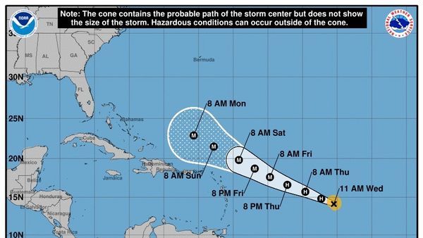
Tropical Storm Lee could become an ‘extremely dangerous major hurricane’ by this weekend (Image Credit: Space.com)
Tropical Storm Lee could potentially strengthen into an “extremely dangerous major hurricane” in the Atlantic Ocean by this weekend, the National Hurricane Center (NHC) reports.
Forecasters are monitoring the tropical storm’s path and “are confident” that it will next careen toward the Leeward Islands, a cluster of islands that includes the U.S. Virgin Islands and is located where the Atlantic meets the Caribbean Sea, according to The Washington Post.
The NHC projects that Lee could reach “hurricane strength very soon, and to a major hurricane within 48 hours,” the NHC wrote in its Wednesday (Sept. 6) forecast. “Continued strengthen[ing] seems likely after that time, but hard-to-predict eyewall replacement cycles could cause some fluctuations in intensity later in the weekend and early next week.”
Related: Hurricane Idalia slams into Florida as astronauts and satellites track it from space (video, photos)
Currently, Lee is situated roughly 1,200 miles (1,930 kilometers) east of the northern Leeward Islands, with winds at approximately 70 mph (113 km/h), and is sweeping west-northwest at 14 mph (22 km/h), according to the forecast.
Lee became a tropical storm on Tuesday (Sept. 5) after forming over the central tropical Atlantic, according to the NHC. If it reaches at least 74 mph (119 km/h), it will be considered a Category 1 on the Saffir-Simpson Hurricane Wind Scale.
As Lee continues its momentum to the west-northwest, favorable conditions will likely help it become a full-fledged hurricane, including “plenty of moisture, low wind shear and abnormally warm water [that] stretch nearly the entire length of [its] projected path,” CNN reported.
Lee is not expected to impact the United States at this time, according to CBS News.
It would be the fourth tropical storm to become a hurricane this season, following in the paths of Don, Franklin and Idalia, according to CNN.


