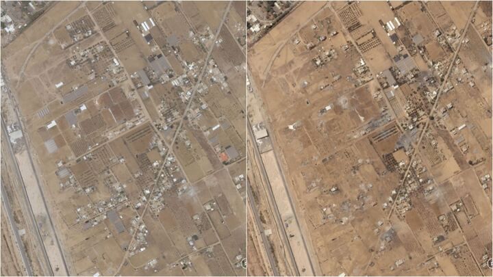
Satellite images of Rafah illustrate Palestinians fleeing the city (Image Credit: Space.com)
Satellite images taken earlier this month offer a spaceborne perspective of the ongoing Israel-Hamas war. They include scenes such as a before-and-after sequence that illustrates Palestinian civilians fleeing Rafah, a view of damaged buildings in the region and conglomerates of Israeli hardware.
For the past several months, Israeli Defense Forces (IDF) have destroyed major portions of areas in which Palestinian civilians live as a response to the Oct. 7 terrorist attack in Israel, an attack orchestrated by the radical militant group Hamas. As Reuters reported on May 14, Israel says Hamas killed more than 1,200 people, mostly civilians, and took 253 people to captivity in Gaza; the Palestinian Health Authorities say the IDF’s military campaign since then has killed more than 35,000 people, also mostly civilians, and has driven 2.3 million people from their homes.
More than 1 million Palestinian refugees have been sheltering in the city of Rafah, most of whom were displaced after the bulk of northern Gaza was decimated due to Israeli air- and ground-based strikes. The IDF recently began requesting that the refugees evacuate from Rafah as well, suggesting impending military action in the area despite warnings from allies including the U.S. that a major military operation there would be devastating for the Palestinian civilian population. Some of the recent satellite images were captured after Israeli Defense Forces seized control of Gaza’s Rafah border crossing ahead of the possible ground-based invasion.
Related: Elon Musk, Israel agree on use of SpaceX Starlink satellite internet in Gaza
More specifically, Palestinians were told to move to an “expanded humanitarian area” in al-Mawasi and Khan Younis, according to NPR, which are north and northwest of the city. Satellite imagery obtained by Planet Labs shows the extent of the tents in Rafah on May 5 and May 8.

A CNN analysis of the satellite images identified “several camps sheltering Gaza’s vast refugee population — including the main camp in central Rafah that housed thousands of tents,” and found that the camps have significantly decreased in size between May 7 and May 8. It was on May 6 when evacuation orders were sent to those sheltering in Rafah, through phone messages and leaflets dropped from overhead. From a non-space-based perspective, NPR reporters said they saw people “frantically packing their belongings and fleeing the area on foot.”
The New York Times analyzed the satellite images as well, highlighting aspects such as damaged buildings “reaching more than two miles into the territory near Rafah’s border crossing with Egypt,” as well as rising smoke nearby and stationed Israeli tanks. “While it is not possible to know exactly what caused the damage shown in the satellite imagery, much of what can be seen is consistent with the aftermath of clearing operations and other Israeli ground operations elsewhere in the Gaza Strip,” the New York Times reports.


As of May 14, The United Nations agency for Palestinian refugees said that about 360,000 Palestinians have been able to leave Rafah over the past week, out of the approximately 1.3 million who had been sheltering there. Many countries have called for a ceasefire to the war, including those who say Israel’s actions constitute a genocide; individuals across the world have spoken in favor of both sentiments as well, including students and academic experts. This past Sunday, U.N. Secretary-General Antonio Guterres urged for “an immediate humanitarian cease-fire, the unconditional release of all hostages, and an immediate surge in humanitarian aid.”
“A ceasefire will only be the start,” he said. “It will be a long road back from the devastation and trauma of this war.”


