Earth from space: Bizarre ‘pet cloud’ reappears above its favorite spot in New Zealand (Image Credit: Space.com)
QUICK FACTS
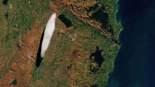
Where is it? Otago region, New Zealand [-45.39649095, 170.20379599]
What’s in the photo? An elongated lenticular cloud known as the “Taieri Pet”
Which satellite took the photo? Landsat 8
When was it taken? Sept. 7, 2024
A peculiar “pet cloud” took center stage in a recent satellite photo of New Zealand. The freaky formation often appears in the same spot thanks to a nearby mountain range — and is sometimes confused with a UFO.
The wispy oblong, known by locals as the “Taieri Pet,” is an elongated altocumulus standing lenticular cloud (ASLC) that frequently appears between the towns Middlemarch and Hyde in the Otago region of New Zealand’s South Island. Although they can vary slightly in size, the clouds always look very similar and appear in almost the same spot. The example in this image is around 7 miles (11.5 kilometers) long.
ASLCs form when waves of air pass over a topographic barrier, like a mountain range, forcing water vapor to condense into vertical layers, according to the National Weather Service. The Taieri Pet forms when moist air passes over the mountainous Rock and Pillar Range (located parallel to the left of the cloud in the photo) and is held in place and further shaped by perpendicular winds blowing from the north, according to NASA’s Earth Observatory.
“As the cloud forms on the crest of this wave, it remains almost stationary in the sky and is shaped by the strong winds blowing through it,” John Law, a meteorologist with New Zealand’s MetService, told Earth Observatory.
Related: UFO-shaped clouds invade skies over Keck Observatory in Hawaii (photos)
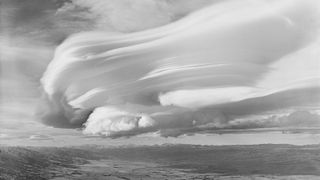
Lenticular clouds are often shaped like flying saucers and are “believed to be one of the most common explanations for UFO sightings across the world,” according to the U.K. Met Office.
When viewed side-on, the Taieri Pet often has multiple well-defined layers on top of one another, like a “huge stack of pancakes” or a “pile of plates,” Earth Observatory representatives wrote. Past photos of the cloud show it can be several hundred feet tall.
The height of lenticular clouds can make them a surprising aviation risk. Planes can experience severe turbulence when flying through the structures, due to vertical currents that run up and down through the cloud. The clouds’ unusually low temperatures also cause ice to form on planes, according to the U.K. Met Office.
ASLCs can be a sign that atmospheric conditions are about to change and are often followed by increased levels of precipitation, according to Fox Weather. However, historical weather data suggest this did not happen in this case.


