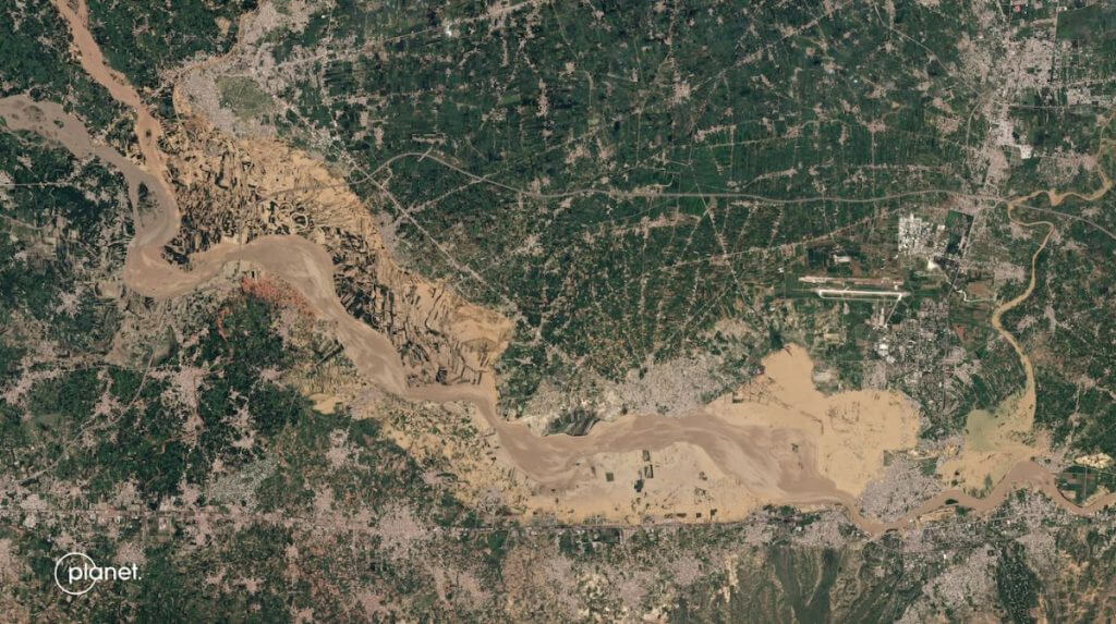
Devastating Pakistan floods seen from space (satellite photos) (Image Credit: Space.com)
Pakistan’s flood-induced pain is visible from space.
Powerful monsoon rains this summer have turned many Pakistan rivers into raging torrents that have washed away much of the mountainous nation’s infrastructure. Since June, those floodwaters have killed more than 1,100 people and damaged over a million homes, according to Pakistan’s National Disaster Management Agency (opens in new tab).
Satellites have been helping the world keep tabs on this unfolding disaster, which has already impacted 33 million of Pakistan’s 240 million people, according to CNN (opens in new tab). For example, the San Francisco-based company Planet posted on Twitter Monday (Aug. 29) before-and-after imagery of two areas swamped by muddy floodwaters.
Related: Planet satellites’ photos of Earth from space (gallery)
Devastating floods, driven by unusually heavy monsoon rains, are surging across Pakistan. Before and after PlanetScope imagery captured of Mianwali and a portion of the Kabul River show widespread damage. pic.twitter.com/Fdh1c7alzwAugust 29, 2022
“Devastating floods, driven by unusually heavy monsoon rains, are surging across Pakistan. Before and after PlanetScope imagery captured of Mianwali and a portion of the Kabul River show widespread damage,” Planet wrote in the Twitter post (opens in new tab).
PlanetScope is the company’s constellation of roughly 130 Earth-observing “Dove” cubesats, each of which is about the size of a loaf of bread. Doves may be small, but they’re pretty sharp-eyed; the cubesats are capable of resolving features as small as 10 feet (3 meters) across from their perch in low Earth orbit.

Big, government-run satellites are keeping tabs on the Pakistan floods as well — including the two spacecraft that make up Sentinel-2, a mission that’s part of the European Union’s Copernicus Earth-observation program.
“The apocalyptic situation caused by the ongoing #floods in #Pakistan is visible from #Copernicus #Sentinel2’s orbit at 786 km [488 miles] in space. This is how the Jafarabad District appeared in the image captured on 29 August 2022,” Copernicus officials said today (Aug. 30) in a Twitter post (opens in new tab) that shared imagery of the ravaged region.
#PakistanFlood 2/2The apocalyptic situation caused by the ongoing #floods in #Pakistan 🇵🇰 is visible from #Copernicus #Sentinel2’s 🇪🇺🛰️ orbit at 786 km in space⬇️This is how the Jafarabad District appeared in the image captured on 29 August 2022 pic.twitter.com/DCeTkcxTQXAugust 30, 2022
The Pakistan floods are another example of extreme weather events that experts say are driven at least in part by human-induced climate change. António Guterres, the secretary general of the United Nations, urged the world to view the disaster through that lens and to take the appropriate action — both over the short term, to help Pakistan, and over the long haul, to help the world at large.
“Let’s stop sleepwalking towards the destruction of our planet by climate change,” Guterres said yesterday, according to CNN. “Today, it’s Pakistan. Tomorrow, it could be your country.”
Mike Wall is the author of “Out There (opens in new tab)” (Grand Central Publishing, 2018; illustrated by Karl Tate), a book about the search for alien life. Follow him on Twitter @michaeldwall (opens in new tab). Follow us on Twitter @Spacedotcom (opens in new tab) or on Facebook (opens in new tab).


