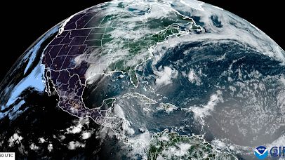
Saharan dust outbreak lingers across some US states this week (Image Credit: Space.com)
From the late spring to early fall, the Saharan Air layer, a large plume of super dry and very dusty air that originates over the Saharan Desert in Africa makes a trek more than 5,000 miles (8,047 kilometers) across the Atlantic toward the United States.
These dust storms happen pretty frequently in the summer, during the Saharan Air layer’s peak season. Every three to five days, pockets of dust come off from these storms and can travel to different areas. This week, the mass of dust that began its journey about two weeks ago from Africa spread out across the Gulf Coast states stretching from Florida to Texas, altering the local weather patterns.
“It’s a two-mile thick layer, very thin as far as the grand scheme of the atmosphere, but that dry air can really affect the weather. The dry air can really suppress afternoon clouds and help cool things down but you can still get storms popping in the late afternoon,” Jason Dunion, the National Oceanic and Atmospheric Administration (NOAA)’s Hurricane Program Field Director and a meteorologist, told Space.com. “It also can make for some of your hottest days when these dust outbreaks come overhead in places like Texas and Alabama.”
While researchers expect to see these gigantic dust storms during this time of year, what was most interesting about this particular outbreak was how it didn’t impede Hurricane Beryl while the storm traveled across the Atlantic. Tropical systems need plenty of moisture to form, and when they encounter dust and dry air, that can weaken. Beryl was unfortunately just in the right place at the right time with this wave.
Related: NASA satellite captures Sahara Desert dust plume over the Atlantic Ocean
“Beryl was tucked on the southern side of it. It was still able to feed in that moist tropical air down to the south of the dust outbreak. A lot of that dry air went along with the system that became Beryl as it went through the Caribbean and brought with it a lot of that Saharan dust on the north side of Beryl today [Monday, July 8],” Dunion said. “If a tropical system can stay south enough to protect it from that dry air, it can still intensify. But some of these systems that plow through that dust layer kind of curve to the north, they can really get weakened.”
Researchers can track the outbreaks with satellite imagery collected with instruments like the NOAA’s Geostationary Operational Environmental Satellites (GOES)-R series.
“I think we take it for granted that we’re able to track something like Beryl all the way back to Africa or one of these Saharan dust outbreaks overhead today in the Gulf states; we can track that back two weeks. I think our bigger awareness of what’s happening has really increased,” Dunion said. “It’s still important to look at what’s happening right where you are. That’s why we take our Hurricane Hunters out to study any of these storms. The National Weather Service balloons are measuring that dry air and so I think the satellites help with the bigger picture.
While Saharan Dust storms can cause headaches with the heat and reduced air quality, they also bring out sunrise and sunset chasers hoping to catch quite the tapestry of colors across the sky as the dust particles scatter the sunlight.
“It can make for some really interesting sunsets too; you get that orange glow,” Dunion said. “Definitely sunrise and sunset are the time of day to really appreciate that dust that’s overhead.”


