How saltwater intrusion is wreaking havoc on farms throughout Delmarva (Image Credit: Phys.org)

Saltwater was once known as an invisible threat to farmers and their crops. It would sneak under the soil undetected on the surface until it intruded so far into groundwater that the soil became saltier and led to a decline in crop yields.
On farms throughout the mid-Atlantic states of Delaware, Maryland and Virginia, however, recent years have shown that the once invisible threat has become more visible, with some farms having noticeably large salt patches on and in close proximity to their cropland.
This is a big problem because once those salt patches become visible, that land and the land close to those salt patches, for all intents and purposes, is already unfit for growing certain crops.
A new paper from researchers at UD, the University of Maryland and George Washington University published in Nature Sustainability shows the spread and cost of saltwater intrusion from 2011–2017 in farms located in those mid-Atlantic states.
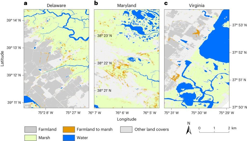
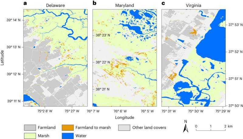
The paper highlights how between the years 2011–2017, the area covered by visible salt patches almost doubled, with over 19,000 acres converted to marsh. Potential economic losses from the salt patches during that time period totaled over $427,000. Sussex County in Delaware showed the most increase in potential losses, estimated at $84,431.
With the rise in salt patches over the time period they covered, the researchers also laid out hypothetical scenarios and found that on farms that grew 100% of corn or soybeans, land within 200 meters of a salt patch might have been experiencing an estimated economic loss of between $39–107 million annually.
The research was led by Pinki Mondal, assistant professor in the Department of Geography and Spatial Sciences who also holds a joint appointment with the Department of Plant and Soil Sciences and is a resident faculty member at the UD Data Science Institute (DSI).
Jarrod Miller, assistant professor in the Department of Plant and Soil Sciences and an Extension Specialist in Agronomy, Matthew Walter, a doctoral candidate in Mondal’s group in the Department of Geography and Spatial Sciences and a DSI fellow, and Vishruta Yawatkar, former master’s degree student in Mondal’s group and currently a doctoral candidate in UD’s Center for Bioinformatics and Computational Biology, were all co-authors on the paper.
Machine learning
Using aerial and satellite images, the researchers trained and tested a machine-learning algorithm by inputting 94,240 reference points from 14 coastal counties in Delaware, Maryland and Virginia. These reference points taught the algorithm how to identify photos by land-type, such as a forest, marsh or salt patch, and tested the accuracy of the algorithm outputs. The research team then analyzed the results to see how those landscapes have changed over the years.
Their results show that the effect of salt patches on agricultural production extends far beyond what is currently mappable. While in some cases, the acreage of land with visible salt patches may be small, its presence denotes that the entire field is at risk of conversion to saline soil that is unsuitable for traditional farming. Additionally, soil salinity in nearby areas of the field may be high enough to reduce crop yield but not enough to leave bare patches.
“From the datasets we developed, what we’re noticing is quite alarming because we see that the salt patches are accruing quite fast,” said Mondal. “The area of farmland with salt patches has almost doubled in the six years we studied. What was more interesting to me was seeing how much of farmland is actually within close proximity to these salt patches. Because when you see these salt patches, that land is already gone. So we also identified farmlands that are pretty close to these salt patches and calculated the extent of it.”
Soil samples
To make sure that the salt patches seen on the photos were indicative of actual salty soil, another part of the research led by other co-authors on the paper involved taking soil samples without consulting the geospatial data. The two research components were conducted in parallelly, and when they collected soil samples and analyzed them for the soil salinity values, the researchers found high salinity levels hundreds of meters away from a visible salt patch.
This is an especially acute problem for corn, one of the biggest crops grown in the Delmarva region which is not very tolerant to salt.
Because Delmarva is such a corn and soy dependent agricultural community, Mondal said there needs to be some short-term solutions farmers can adopt to help mitigate the damages from salt water intrusion.
One of those suggestions is for land-owners to plant crops that are more salt tolerant in the short-term and reduce farm inputs to keep the loss of profit at a minimum. Instead of planting corn, farmers could plant more salt tolerant crops such as sorghum.
Long-term solutions
Ultimately, Mondal said she is more interested in long-term fixes, as the short-term ones will eventually have the same outcome: the fields will have to be abandoned for harvesting crops because they will become too salty.
One possible long-term solution is to proactively convert some farmland into marsh habitat. Mondal said this would provide two solutions: the marshland could be used for wildlife habitat and it could also act as a natural barrier to stop the saltwater encroachment.
“These solutions would all require public policy implementations,” said Mondal. “We hope with our on-going work and with these publicly available datasets that our policy-makers can use them to identify priority areas that can be utilized for new policy implementation and possibly farm-level interventions.”
Because the datasets are so detailed, individual farms can be identified and land-owners can see how they are being impacted by saltwater intrusion.
“Based on that and based on the changing scenarios, these datasets can be utilized for designing certain policies, implementations or designing incentives,” said Mondal. “There are some tax incentives that different agencies work with. If they have access to this information, they could work on implementing those.”
She also noted that this is just the first project from the geospatial research group and that more is on the way.
“We’re working to understand the processes of saltwater intrusion that are behind all of these different salt encroachments onto different land areas,” said Mondal. “There’s a geographical component to it and depending on where we are located, different mechanisms might be dominating this entire situation. We are working to find the answer to those, and many other questions.”
More information:
Pinki Mondal et al, The spread and cost of saltwater intrusion in the US Mid-Atlantic, Nature Sustainability (2023). DOI: 10.1038/s41893-023-01186-6
Journal information:
Nature Sustainability
Provided by
University of Delaware
How saltwater intrusion is wreaking havoc on farms throughout Delmarva (2023, July 28)
retrieved 27 September 2023
from https://phys.org/news/2023-07-saltwater-intrusion-wreaking-havoc-farms.html
part may be reproduced without the written permission. The content is provided for information purposes only.


