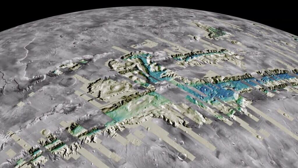
Viewing the Martian landscape is now easier than ever before, thanks to a new map generated from a treasure trove of data collected by NASA’s Mars Reconnaissance Orbiter.
The new map, compiled with the help of supercomputers and cloud computing, provides a high-resolution, three-dimensional experience of Mars‘ otherworldly terrain.
The map, processed by a team at the U.S. Geological Survey‘s (USGS) Astrogeology Science Center, consists of over 4,800 digital terrain models (DTMs) and more than 155,000 images of the Martian surface.
Related: 12 amazing photos from the Perseverance rover’s 1st year on Mars
“Now anyone on the planet with a smartphone can search, use and marvel at these data,” team leader Jay Laura, of the Astrogeology Science Center (ASC), said in a statement.
“These data are important because they democratize the availability of high-quality Mars topographic data,” Laura added. “Getting consistent, well-aligned results is not easy. We felt it was important to generate and release these products so that others could freely access the data. When these data are highly accessible, anyone can contribute to scientific discovery.”
The Martian topographic data used by the team was collected by the Mars Reconnaissance Orbiter‘s (MRO) Context Camera, which can capture images with a resolution of around 6 meters per pixel covering an area of up to around 18.5 miles (30 kilometers) wide and 100 miles (160 km) long.
The team then produced DTMs by overlapping two images of the same area and processing them with a supercomputer to create a detailed 3D view. The process is similar to how visual data collected by both our eyes is processed by the brain to generate our sense of depth perception and create a 3D picture of our surroundings, team members said.
Seamlessly aligning pairs of images to each other and then to the topography of Mars is, however, not as easy as it may sound. First, Laura and the USGS team had to line up individual DTMs to global low-resolution topography and then deliver this information back to the Denali supercomputer, located at the Eros Data Center in Sioux Falls, South Dakota.
This was done in batches of several hundred DTMs at once, requiring a huge amount of computing power and several weeks to process. The procedure would take a standard personal computer between two and 35 years of continuous processing to achieve, team members said.
The 4,800 DTMs are just the tip of the iceberg in terms of Mars data, with the ASC team currently working on thousands of other image pairs that should result in improved topographic coverage of Mars at 20 meters per pixel.
Additionally, the image pairs were collected alongside higher resolution image pairs gathered by another MRO camera, the even sharper-eyed High-Resolution Imaging Science Experiment (HiRISE).
Though they cover smaller patches of Mars’ surface, just 3.7 miles (6 km) wide by 37 miles (60 km) long, the HiRISE images have a resolution of 25 cm (9.8 in) per pixel. This means each HiRISE image is packed with detail but has a huge data size — 1 GB and above, team members said.
Scientists have a tough time dealing with such detailed photos; efforts to do so previously have involved downloading full images in an area of investigation one by one and then processing them so that they can be viewed at different zoom levels.
So the ASC team has worked to process the entire catalog of 155,000 HiRISE images, equivalent to around 114 TB of data, making them streamable and accessible free of charge. During the processing, the data was streamed from the NASA Planetary Data System cloud holdings, with over 4,000 images processed simultaneously and the entire dataset taking just under four hours to complete.
The testing and refining of this processing pipeline ensured that it produced reliable and useful images. This means that analysis can now be conducted in the cloud, and data can be accessed without the need to download whole images. The streamable data can then be examined on a smartphone or downloaded in a ready-to-use format that doesn’t require processing, team members said.
Huge data sets of fully processed images like this have been highlighted by the NASA Planetary Data Ecosystem Independent Review Board as vital in supporting the application of AI and machine learning to planetary science.
“These data are ripe for discovery and use by machines and humans,” Laura said. “This data release means that the HiRISE data set can now be seamlessly leveraged by machine-learning scientists.”
The data is hosted by Amazon in the company’s Open Data Registry, and it is free for anyone to use. In order to make the data easier to find and download, thus ensuring it is more accessible to the general public, the USGS has released search tools for users.
“With data releases like this, USGS is taking the lead to develop and release analysis-ready planetary science data,” Laura concluded.

