


Atmospheric conditions vary significantly at both temporal and spatial scales. The purpose of atmospheric correction based on radiative transfer model is to eliminate the atmospheric radiative effect on remote sensing images, but it is always limited by the difficulty of obtaining atmospheric parameters that match image at temporal and spatial scales.
To retrieve the surface reflectance, scientists from the Hefei Institutes of Physical Science of the Chinese Academy of Sciences have proposed a method to eliminate the influence of atmosphere and the adjacency effects, thus to obtain the true reflectance of ground objects. Relevant results were published in Remote Sensing.
“What we suggested in this experiment is called synchronization atmospheric correction (Syn-AC) method,” said Xu Lingling, first author of the study, “and we used it to retrieve synchronous atmospheric parameters from SMAC.”
They tried it on multi-spectral remote sensing images of Gao Fen Duo Mo (GFDM), the first civilian high-resolution remote sensing satellite equipped with the Synchronization Monitoring Atmospheric Corrector (SMAC), and successfully performed the synchronous atmosphere correction.
Aside from that, they conducted synchronous field-measured experiments to test the performance of Syn-AC.
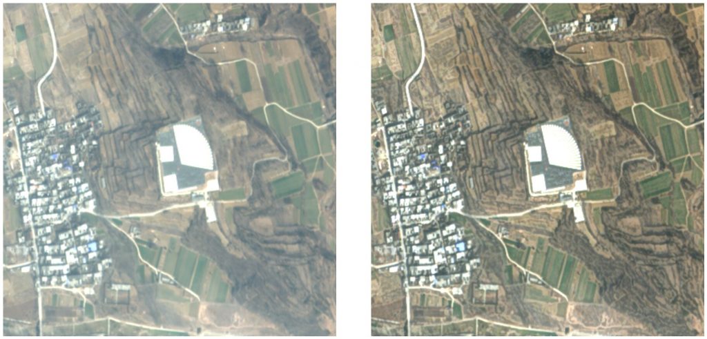
Six images from three radiometric calibration sites (Dunhuang, Songshan and Baotou) under different atmospheric conditions were selected to conduct atmospheric correction experiments. And visual effects before and after atmospheric correction were compared.


They also compared the average reflectance of the selected targets in the surface reflectance image of Syn-AC with the field-measured reflectance values.
The results indicated that the visual effects of corrected image were improved with the blurring effect removed, and the real features of ground objects were effectively recovered.
Atmospheric correction based on synchronous atmospheric parameters could promote the quantitative application of GFDM satellite data.
Explore further
Optimized directional polarization camera helps terrestrial ecosystem carbon monitoring
Lingling Xu et al, Synchronous Atmospheric Correction of High Spatial Resolution Images from Gao Fen Duo Mo Satellite, Remote Sensing (2022). DOI: 10.3390/rs14174427
Synchronous atmospheric correction method proposed for multi-spectral satellite images (2022, September 26)
retrieved 27 September 2022
from https://phys.org/news/2022-09-synchronous-atmospheric-method-multi-spectral-satellite.html
part may be reproduced without the written permission. The content is provided for information purposes only.