


Scientists are tracing the movement of dust over Martian eons using a high-definition camera from orbit.
A Twitter account for the Mars Reconnaissance Orbiter‘s High Resolution Imaging Experiment, at work at Mars since 2006, recently posted a picture of “barchan dunes” formed by the Red Planet’s winds pushing continuously in a single direction.
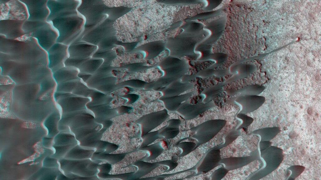
“Now, who doesn’t like an image of dunes in 3D,” the tweet (opens in new tab) said along with the picture. “Pay attention to the sand ‘thread’ on the right side of the image. Interesting how that might have formed.”
Related: The sand dunes of Mars move in a weird way
While mission experts provided few details with the image, scientists have been probing the Nili Patera region for many years now in an attempt to figure out how the dunes evolve over time. A 2012 study, for example, showed remarkably swift movements across 105 days, during which some dunes traveled as much as 15 feet (4.5 meters).
Barchan dunes are formed as the wind slowly moves sand grains up the slope of the dunes, creating small ripples on the slope, NASA reported in 2019.
“When the sand grains arrive at the top, they fall down the steeper and shorter slope, which as a consequence, has no ripples,” the agency wrote in a statement (opens in new tab) at the time. “It is this gradual sand movement that causes the dunes to slowly move over time.”
HiRISE 3D: Dunes in Nili PateraNow, who doesn’t like an image of dunes in 3D? Pay attention to the sand “thread” on the right side of the image. Interesting how that might have formed!https://t.co/VE65NHGniCNASA/JPL-Caltech/UArizona#Mars pic.twitter.com/mgMc03jOZhMay 25, 2022
Scientists are interested in sand dunes because they show areas of constant surface change, rather than the same material getting soaked in ultraviolet or gamma radiation that might erase Martian biosignatures. It’s thought these regions might be fruitful in the ongoing search for Martian life.
Nili Patera is also known for its unique lava flows of basalt and dacite; dacite is quite rare on the Red Planet, implying a “volcanically complex” history in the region, according to an Arizona State University webpage about another long-running NASA spacecraft mission called Mars Odyssey.
Nili Patera forms part of the summit caldera (collapsed volcanic area) of Syrtis Major, from which these strange lavas emanated. The floor is about 6,000 feet (1,800 meters) lower than the western rim, according to Arizona State University.
Follow Elizabeth Howell on Twitter @howellspace. Follow us on Twitter @Spacedotcom and on Facebook.