

Earth-observing satellites have helped detect previously unmapped global fishing vessels, revealing nearly 75% of the world’s industrial activity at sea was “hidden” from public view.
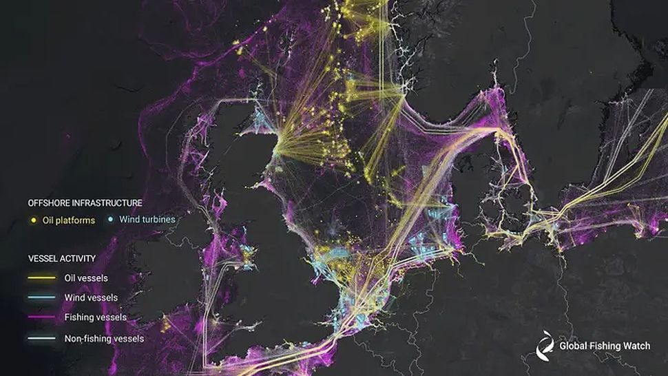
Using satellite imagery from 2017-2021, vessel GPS data and machine learning software, a team led by the Global Fishing Watch created the first world map of large vessel traffic and offshore infrastructure. Their findings bring to light a large number of “dark vessels,” or those that previously didn’t appear in public monitoring systems, offering a better understanding of the global impact of human activity at sea.
The new maps, which have been made public, offer a more complete view of ocean industrialization, which can help researchers tackle global concerns such as climate change. Having a more comprehensive view of vessel traffic will improve estimates of greenhouse gas emissions at sea and hold the parties responsible for marine pollution accountable.
“By seeing and characterizing the activity of these expansive dark fleets, we can begin to better understand and quantify not just illegal fishing but a great deal of human activity that is impacting our marine environment,” Paul Woods, chief innovation officer of Global Fishing Watch, said in a statement from the organization. “These are exciting times when it comes to open, accessible data that anyone can use for free to understand and advocate for the fragile marine areas they care about most.”
Related: Satellites uncover widespread illegal fishing in Pacific Ocean
The team’s analysis showed that 75 percent of the world’s industrial fishing vessels and more than 25 percent of transport and energy vessels are not publicly tracked, which presents challenges for managing natural resources such as protected marine areas, according to the study.
Most of the unmapped industrial fishing vessels were found around Africa and south Asia. While there are a number of legitimate reasons why a vessel might not appear in a public monitoring system, many of the unmapped vessels are often engaged in illegal, unreported and unregulated fishing, according to the statement.

“A new industrial revolution has been emerging in our seas undetected — until now,” David Kroodsma, director of research and innovation at Global Fishing Watch and co-lead author of the study, said in another statement announcing the findings. “On land, we have detailed maps of almost every road and building on the planet. In contrast, growth in our ocean has been largely hidden from public view. This study helps eliminate the blind spots and shed light on the breadth and intensity of human activity at sea.”
The team was able to identify the location of vessels and offshore infrastructure in coastal waters across six continents where more than 75% of industrial activity is concentrated. This, in turn, revealed changing trends in fishing activity, which dropped globally by about 12 percent during the COVID-19 pandemic.
Meanwhile, offshore energy development, such as oil drilling and wind turbines, increased significantly, but transport and energy vessel activity remained stable.
“Historically, vessel activity has been poorly documented, limiting our understanding of how the world’s largest public resource — the ocean — is being used,” Fernando Paolo, co-lead author and senior machine learning engineer at Global Fishing Watch, said in the second statement. “By combining space technology with state-of-the-art machine learning, we mapped undisclosed industrial activity at sea on a scale never done before.”
Their findings were published Jan 3 in the journal Nature.