


The U.S. Northeast woke up to a “horribly smoky day” on Wednesday (June 7), as a low-pressure system funnels toxic smoke from wildfires in Canada across the Atlantic Coast.
The beige-tinged haze can be seen in imagery captured by the weather forecasting satellite GOES East, but plentiful eyewitness reports of the smoke have also cropped up on social media since Tuesday afternoon (June 6).
Boston-based air-quality researcher Sotirios Papathanasiou shared an eerie photograph of a setting sun surrounded by a neon-bright orange halo Tuesday evening, explaining that the sight is more dangerous than mesmerizing.
“Many will think that this is a nice sunset but in reality this is a toxic sunset as it indicates the presence of tiny particles in the atmosphere and in the breathable air,” Papathanasiou said in a tweet. “Don’t stay outside for a long time and wear N95 masks.”
Related: NASA’s new air pollution sensor will monitor smog above America in real time


NASA researcher Ryan Stauffer said that concentrations of tiny ash particles in the atmosphere — the so-called PM 2.5s — in New York, Philadelphia and other cities in the region will likely hit record highs on Wednesday.
“The smoke PM2.5 values coming in this evening are extraordinary,” Stauffer said in a tweet on Tuesday evening. “Today and tomorrow will rival, and in some cases may surpass the event of record for the region, July 7th 2002.”
According to NBC News, air quality alerts have been put in place in 13 U.S. states as of Wednesday morning.
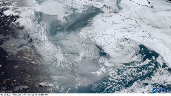
Today’s horribly smoky day in the Eastern US as seen by satellite. pic.twitter.com/6iY5QjQqm8June 7, 2023
The air pollution comes from smoke generated by dozens of wildfires that have been blazing through the Canadian provinces of Quebec and Nova Scotia in recent weeks. A large area of low air pressure that is currently swirling above the northwestern parts of the Atlantic Ocean is funneling the pollution southward. According to predictions, the ash cloud may affect air quality as far as South Carolina.
“Today’s horribly smoky day in the Eastern U.S. as seen by satellite,” the Cooperative Institute for Research in the Atmosphere at Colorado State University tweeted, along with an image showing the beige-tinged river of air pollution being pushed southward by a rotating mass of thick white clouds.
The images were obtained by GOES East, a geostationary weather satellite operated by the U.S. National Oceanic and Atmospheric Administration that constantly monitors the eastern parts of North America and the adjacent Atlantic Ocean.
NASA satellites, too, have been keeping an eye on the wildfires, which are burning with unprecedented ferocity this year, following a period of exceptionally high temperatures in early May and an unusually dry spring.
According to NASA, only about 1 square mile (2.6 square kilometers) of land burns in Quebec by early June during an average wildfire season. This year, 600 square miles (1,550 square km) of land have already been ravaged by blazes, which wildland firefighters have had a very hard time controlling.