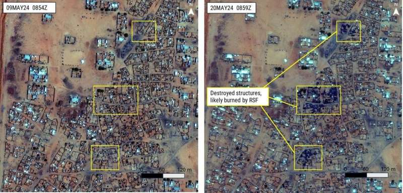
On April 15, 2023, intense violence erupted in Sudan’s capital city of Khartoum between the state-run military and a non-state militia group. Over the past 16 months, the conflict has continued to expand in scale. Peace negotiations have collapsed. Civilians have experienced catastrophic humanitarian conditions.
George Mason University’s Daniel Rothbart has for many years investigated the plight of civilians in war globally. He believes that out of the 59 protracted violent conflicts around the world, the civil war in Sudan is among the most horrific.
“This conflict has had catastrophic humanitarian implications,” explained Rothbart, the Druscilla French Chair in Conflict Analysis and Resolution in the Jimmy and Rosalyn Carter School of Conflict Analysis and Resolution.
“There have been an estimated 16,000 fatalities and numerous cities destroyed. Right now, Sudan has the largest number of internally displaced persons in the world at 10.7 million people.”
As peace talks failed and conflict escalated, the Conflict Observatory, managed by the MITRE Corp, approached Rothbart and the Carter School to support an investigation into the human rights violations associated with the civil war.
In areas of violent conflict, scholars like Rothbart must find remote methods of data collection. One such method is through Open Source Investigations (OSINT), where publicly and commercially available information, such as satellite imagery, social media posts, and news reports, is collected and analyzed.
Because the Conflict Observatory specifically requested satellite imagery evidence, Rothbart enlisted a team of researchers from the College of Science’s Department of Geography and Geoinformation Science, including department chair Dieter Pfoser, to gather and analyze the images.
Through this method, they can show side-by-side images of the large-scale destruction of civilian areas over the course of the conflict, such as markets, neighborhoods, and health care facilities.
This is a valuable kind of data for understanding the impact and trend of protracted violence, Rothbart said. “It captures the evolution of events over time in a particular region, and the amount of detail these experts are able to gleam from these images has been used to great effect.”
As detailed in the report, the experts can distinguish between a building burned and a building bombed: important evidence for building a future case in prosecuting human rights violations.
But satellite imaging only tells part of the story of the destruction and devastation. Other information comes from witness testimonies, which Rothbart and his team gather with the help of the Sudan Human Rights Hub. By combining these two methods of data collection, they can paint a more robust picture of the breadth and depth of violence.
“For example, with both testimonies and open-source intelligence, we have documented that some militant forces have systematically killed civilians, bombed hospitals, and engaged in large-scale gender-based violence, ” Rothbart said.
Through these reports, Rothbart and his team are the primary source of evidence of civilian devastation in the war in Sudan. And while the evidence submitted by the team is under the discretion of the State Department, it could be used to prosecute the perpetrators of the described human rights violations.
The project is also an opportunity for students to gain valuable experience. Current conflict analysis and resolution Ph.D. student Beltina Gjeloshi, and alumnus Mathieu Bere, Ph.D. Conflict Analysis and Resolution ’22, are both supporting members of Rothbart’s team.
“I’ve learned best practices in open-source investigations, a myriad of new digital tools, and how to capture evidence via different channels, such as satellite images and social media,” said Gjeloshi. “Coupling the training with my human rights and conflict resolution background has allowed me to formulate unique insights and use tools transdisciplinarily.”
“This deliberate violence against civilians requires that the international community takes measures to enforce international humanitarian law, protect civilians, and hold perpetrators accountable. The work that we have been doing on this project contributes to the fulfillment of that moral and legal requirement,” said Bere.
“On a purely academic and scientific side, we have been using, and hope to contribute to improve, some innovative technological tools, especially OSINT and GIS tools, for remotely monitoring and documenting what is happening in conflict zones, and for conducting real-time conflict research,” said Bere.
“For example, we are exploring the possibility of developing an AI model that will facilitate some of the steps of the data-gathering process that may be automated. The project is an interdisciplinary work, which requires collaboration between experts from various disciplines.”
Every conflict is unique, but there are repeated patterns in motivations, actions, and strategies. Rothbart hopes that the global peace community can learn from why and how peace talks have been unsuccessful in Sudan to improve their approaches to other protracted conflicts.
“We must be prepared to recognize that under certain conditions human beings can commit horrific acts,” Rothbart explained. “But in every case of protracted violent conflict, we find human beings who show an enormous degree of courageous compassion in the face of horrific violence. And that’s important to keep in mind.”
Provided by
George Mason University
Satellite imagery could aid in seeking justice for human rights violations in Sudan (2024, August 22)
retrieved 23 August 2024
from https://phys.org/news/2024-08-satellite-imagery-aid-justice-human.html
part may be reproduced without the written permission. The content is provided for information purposes only.