

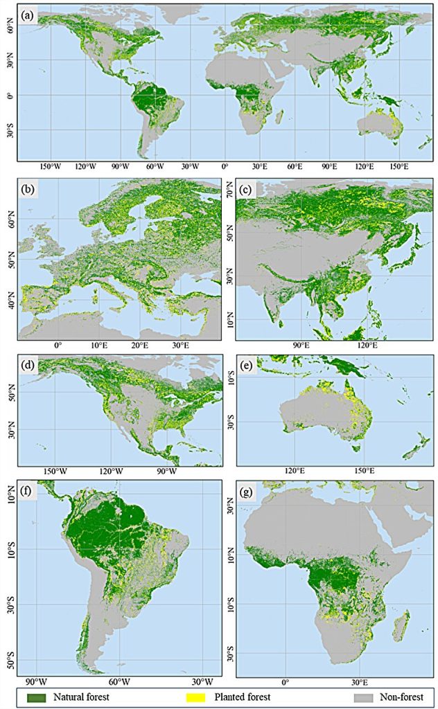

 Global; (b) Europe; (c) Asia; (d) North America; (e) Oceania; (f) South America; (g) Africa. Credit: Yuelong Xiao, Tongji University")
While planting trees may seem like an easy win to combat climate change, planted forests often encroach on natural forests, wetlands, and grasslands. This can reduce biodiversity, disturb the natural environment, and disrupt carbon and water cycling.
While there has been a global increase in forest cover, it’s hard to know if this forest is the regeneration and growth of natural forests or if it is planting new trees. Accurately mapping these forests with remote sensing technology could help.
However, comprehensive maps of planted forests and natural forests are lacking, even though it is possible to distinguish planted forests and natural forests on satellite images based on their characteristics.
A study published on 21 August in the Journal of Remote Sensing presented an innovative approach to automatically generate training samples so natural forests and planted forests can be accurately mapped at 30-m spatial resolution.
“Accurately mapping the global distribution of natural and planted forests at a fine spatial resolution is a challenge, but it is crucial for understanding and mitigating environmental issues such as carbon sequestration and biodiversity loss,” said Yuelong Xiao, a doctoral student at the College of Surveying and Geo-Informatics at Tongji University in Shanghai, China.
“Traditional methods often lack sufficient training samples, which hampers the accuracy and resolution of global forest maps. Our study presents a novel approach to overcome this limitation by generating extensive training samples through time-series analysis of Landsat images.”
The researchers sourced data from several different mapping systems. The primary sources were Google Earth Engine’s Landsat images ranging from 1985 to 2021 that were preprocessed by the US Geological Survey and images from the Sentinel-1 satellite from 2021.
They also used the 2021 European Space Agency land cover maps, called WorldCover2021, and data from the ALOS Global Digital Surface Model. To work around computing limitations, researchers divided the globe into small tiles, resulting in 57,559 tiles covering the entire globe and 70 million training samples.
To distinguish between established natural forests and planted forests, researchers used a value called the frequency of disturbance. Natural forests are more stable and are less likely to change in size based on external factors.
In comparison, planted forests are more likely to be disturbed through reforestation or deforestation and other natural and manmade changes. By tracking the frequency of disturbance of a forested area on a satellite image, natural forests and planted forests can be identified.
Planted forests were considered pixels with a frequency of disturbance value greater than three. The value was calculated based on the number of disturbance events, such as planting events, and the reliability of the training samples. Natural forests had no disturbance events. Researchers also accounted for the fact that all of their images were from 1985 and later.
To account for planted forests that may be older than 1985, they used other features and characteristics to distinguish between natural and planted forests. Finally, to determine the accuracy of their training model, researchers compared their natural vs. planted forest maps with other studies.
The research demonstrated that a less labor-intensive mapping method using autogenerated training samples to distinguish between natural and planted forests is possible.
“This method to accurately map natural and planted forests globally at a 30 meter resolution is reliable and the generated map and training samples represent a valuable resource for future research and environmental management, contributing to efforts in combating climate change,” said Xiao.
Looking ahead, researchers are hoping to integrate improvements into the map system.
“Next, we will use the generated training samples and method mapping to update and refine the global map of natural and planted forests regularly. Our ultimate goal is to enhance the accuracy and resolution of forest maps worldwide, providing critical data for policymakers and researchers,” said Xiao.
Other contributors include Qunming Wang at Tongji University in Shanghai, China and Hankui K. Zhang at South Dakota State University in Brookings, South Dakota.
More information:
Yuelong Xiao et al, Global Natural and Planted Forests Mapping at Fine Spatial Resolution of 30 m, Journal of Remote Sensing (2024). DOI: 10.34133/remotesensing.0204
Provided by
Journal of Remote Sensing
Researchers use training model to map planted and natural forests via satellite image (2024, September 16)
retrieved 17 September 2024
from https://phys.org/news/2024-09-natural-forests-satellite-image.html
part may be reproduced without the written permission. The content is provided for information purposes only.