


. DOI: 10.1007/s10844-024-00877-6")
Forests and woodlands cover one third of Earth’s surface and play a critical role in carbon sequestration, water regulation, timber production, soil protection, and biodiversity conservation. Accelerated by climate change, the decline of these and other key forest ecosystem services is caused by various biotic and abiotic disturbances. Among them, insect infestations and disease outbreaks can induce massive tree dieback and significantly disrupt ecosystem dynamics.
Forest surveillance is crucial to monitor, quantify and possibly prevent such events. However, most common strategies primarily rely on laborious and time-consuming field surveys, restricting geographical coverage and preventing large-scale analysis across vast territories.
On the other hand, the large amounts of remote sensing information collected via Earth observation missions constitutes an unprecedented opportunity to scale up forest dieback assessment and surveillance over large areas.
In a study published in the Journal of Intelligent Information Systems, researchers from the University of Bary Aldo Moro, Italy, and collaborators explore the performance of a data-centric semantic segmentation approach to detect forest tree dieback events due to bark beetle infestation in satellite images.
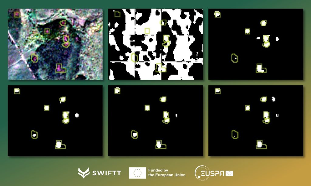
Named DIAMANTE (Data-centrIc semAntic segMentation to mAp iNfestations in saTellite imagEs), their approach trains a U-Net-like model from a labeled remote-sensing dataset prepared using both Copernicus Sentinel-1’s SAR data and Sentinel-2’s multi-spectral optical data.
The authors evaluated the effectiveness of their approach using a real inventory case study of non-overlapping forest scenes from northeastern France acquired in October 2018, which host bark beetle infestation hotspots of different sizes originating from the mass reproduction of the bark beetles that year.
Their results highlight the general advantages of using multisensor data over a single data source in various scenarios of bark beetle detection, including early disease detection and out-of-year temporal transfer. While Sentinel-1 alone is not suitable for the considered downstream mapping task, using Sentinel-2 alone yields satisfactory results. Additionally, their combined use significantly reduces false alarms and improves the delineation of infested areas in the resulting binary maps.
In particular, signs of bark beetle attacks could be detected with reasonable accuracy one month before the acquisition of ground truth data. However, the disease’s earlier stages are weakly detectable via satellite imagery.
As such, there is still room for research activities in the way historical data can be leveraged for temporal and spatial transferability, i.e., the direct deployment of a model trained on a particular area or time period to a different area or time period.
More information:
Giuseppina Andresini et al, DIAMANTE: A data-centric semantic segmentation approach to map tree dieback induced by bark beetle infestations via satellite images, Journal of Intelligent Information Systems (2024). DOI: 10.1007/s10844-024-00877-6
Provided by
Da Vinci Labs
Researchers explore novel approach to map forest dieback in satellite images (2024, September 25)
retrieved 26 September 2024
from https://phys.org/news/2024-09-explore-approach-forest-dieback-satellite.html
part may be reproduced without the written permission. The content is provided for information purposes only.